MapsGPT
Open siteOffice & Productivity
Introduction
Create customized maps with pins quickly using MapsGPT, an OpenAI and Proxi powered tool.
MapsGPT Product Information
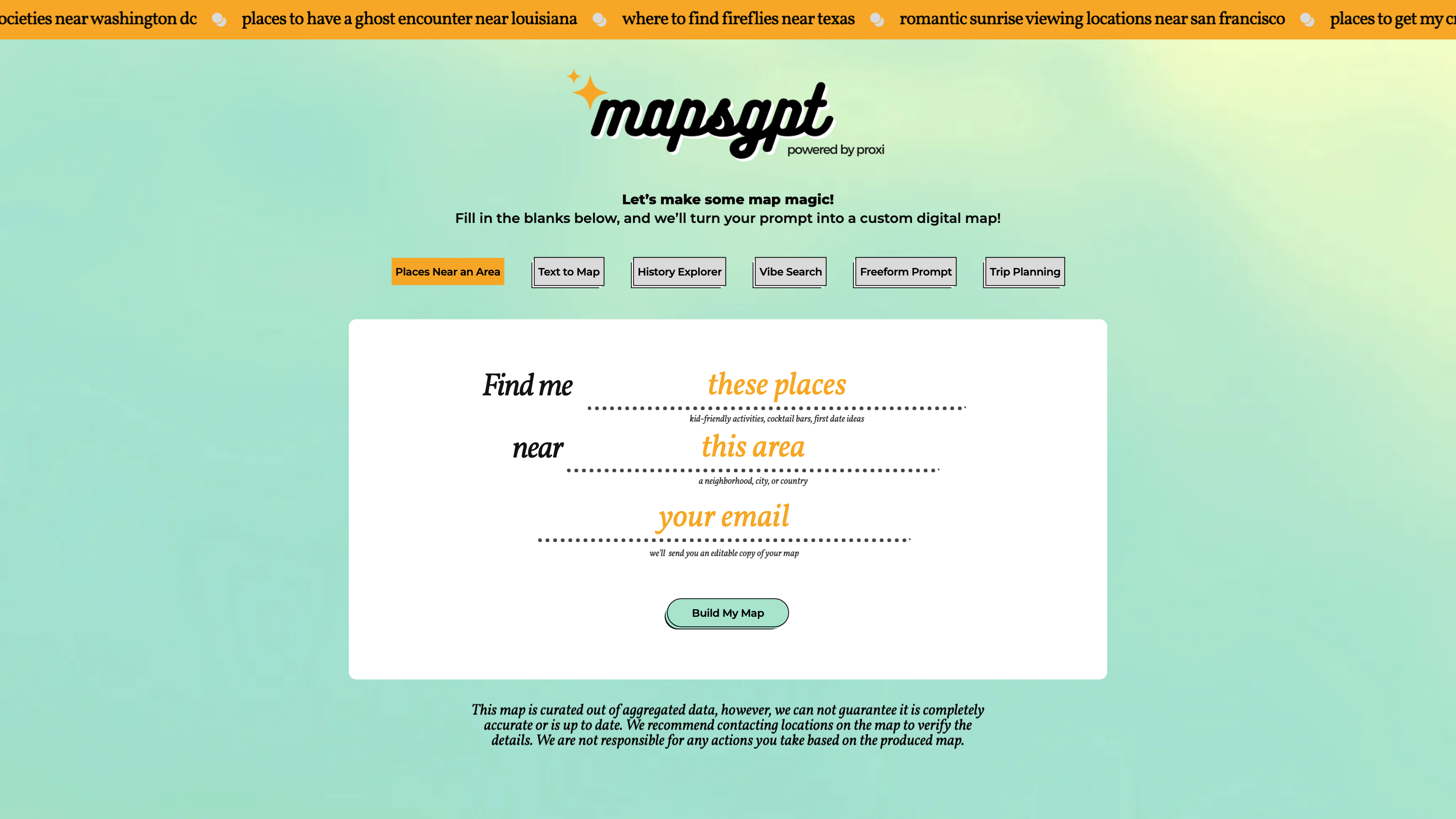
Create A Custom Map With Pins In Seconds | MapsGPT is a map generation tool that converts natural language prompts into customizable, pin-filled digital maps in moments. Integrated with Proxi, it lets you revisit, edit, and share maps created from prompts, enabling rapid trip planning, event ideas, and location-based explorations. The platform supports multiple input styles and transformation options to turn plain text, images, spreadsheets, or URLs into interactive maps.
How it works
- Describe your map prompt (e.g., center location, areas of interest, vibe, or specific venues).
- The tool renders an editable map with pins, paths, and labels based on your text input.
- Save, share, or export an editable copy of your map for collaboration or future reference.
If the initial submission fails, you can retry, adjust the prompt, or switch to alternative mapping methods (image-to-map, spreadsheet-to-map, or URL-to-map).
Input Methods
- Text Prompt: Describe the center, search areas, and vibe to generate a map.
- Image-to-Map: Turn PNGs, JPGs, and PDFs into interactive maps.
- Spreadsheet-to-Map: Convert tabular data into pins and routes instantly.
- URL-to-Map: Transform web content (blogs, travel sites) into mapped experiences.
Use Cases
- Plan a day trip for a specific group (e.g., foodies, families).
- Find coffee/cocktail spots, first-date ideas, kid-friendly activities near a location.
- Create thematic maps (artsier, edgy, spooky, boomer-friendly, healthy vibe) around a city or neighborhood.
- Visualize historical places or points of interest near a defined area.
- Generate maps for events, tours, or social outings with editable copies for collaboration.
Output and Sharing
- You’ll receive an editable copy of your map for further customization.
- Maps load quickly and can be shared via link or exported for offline use.
- The platform may display status messages (e.g., “Your map will load in just a sec.”) and offers retry options if submissions fail.
How It Works (Key Features)
- Convert natural language prompts into interactive maps with pins.
- Revisit and edit previously created maps by logging into your Proxi account.
- Multiple input modalities: text prompts, image-to-map, spreadsheet-to-map, and URL-to-map.
- Instant rendering with editable copies for collaboration and planning.
- Plan trips, identify venues, and map points of interest around a central area.
- Supports a variety of search criteria: area of interest, continent, city, neighborhood, or country.
- Shareable maps with exported or embeddable formats.
- Real-time status updates and retry options for failed submissions.
Safety and Accuracy Considerations
- Maps are generated from aggregated data; always verify details with locations before making plans.
- The service provides editable maps but does not guarantee real-time accuracy for all points.
Quick Start
- Enter a center area and prompts like “coffee and cocktail bars near [city]” or “first date ideas near [neighborhood].”
- Choose your input method (text, image, spreadsheet, URL).
- Generate your map and refine pins, categories, and labels as needed.
Tech/Platform Notes
- Built for rapid map creation and collaboration within the Proxi ecosystem.
- Focused on ease of use, speed, and flexible data ingestion for diverse mapping needs.